| Description |
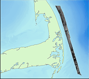
This data set includes backscatter intensity of the sea floor offshore of eastern Cape Cod, Massachusetts. The data were collected with a multibeam sea floor mapping system during USGS survey 98015, conducted November 9 - 25, 1998. The surveys were conducted using a Simrad EM 1000 multibeam echo sounder mounted aboard the Canadian Coast Guard vessel Frederick G. Creed. This multibeam system utilizes 60 electronically aimed receive beams spaced at intervals of 2.5 degrees that insonify a strip of sea floor up to 7.5 times the water depth (swath width of 100 to 200 m within the survey area). The horizontal resolution of the beam on the sea floor is approximately 10% of the water depth. Vertical resolution is approximately 1 percent of the water depth. With backscatter intensity, the intensity of the acoustic return from the sea floor from the multibeam system, is a function of the properties of the surficial sediments and of the bottom roughness. Generally, a strong return (light gray tones) is associated with rock or coarse-grained sediment, and a weak return (dark gray tones) with fine-grained sediments. However, the micro-topography, such as ripples, burrows, and benthic populations also affect the reflectivity of the sea floor. Direct observations, using bottom photography or video, and surface samples, are needed to verify interpretations of the backscatter intensity data. The backscatter data have a weak striping that runs parallel to the ship's track. Some of the striping is the result of poor data return at nadir that appears as evenly-spaced thin speckled lines. Some striping is also due to critical angle effects, where the intensity of return varies as a function of the angle of incidence of the incoming sound on the seafloor (Hughes-Clark and others, 1997). [More]
|
