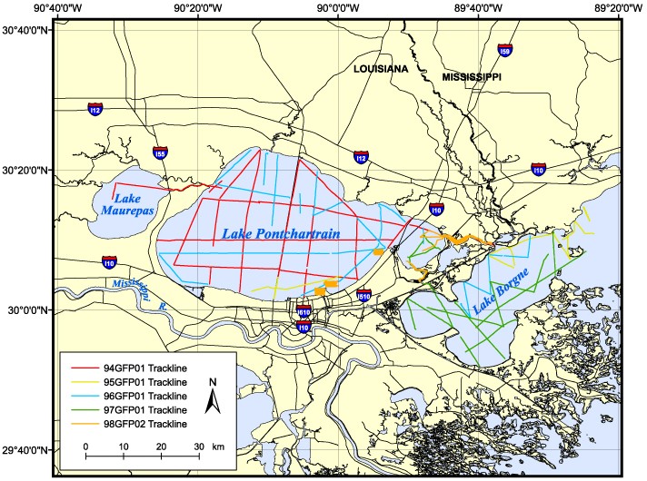
| Description |
The U.S. Geological Survey, in cooperation with the University of New Orleans, the Lake Pontchartrain Basin Foundation, the National Oceanic and Atmospheric Administration, the Coalition to Restore Coastal Louisiana, the U.S. Army Corps of Engineers, the Environmental Protection Agency, and the University of Georgia, conducted five geophysical surveys of Lakes Pontchartrain, Borgne, and Maurepas in Louisiana from 1994 to 1998. This report serves as an archive of unprocessed digital boomer seismic reflection data, trackline maps, navigation files, observers' logbooks, GIS information, and formal FGDC metadata. In addition, a filtered and gained GIF image of each seismic profile is provided. The archived trace data are in standard Society of Exploration Geophysicists (SEG) SEG-Y format (Barry and others, 1975) and may be downloaded and processed with commercial or public domain software such as Seismic Unix (SU). Examples of SU processing scripts and in-house (USGS) software for viewing SEG-Y headers (Zihlman, 1992) are also provided. Processed profile images, trackline maps, navigation files, Field Activity Collection System (FACS) logs, and formal metadata may be viewed with a web browser, and scanned handwritten logbooks may be viewed with Adobe Reader. For more information on the seismic surveys see http://woodshole.er.usgs.gov/operations/ia/public_ds_info.php?fa=1994-030-FA , http://woodshole.er.usgs.gov/operations/ia/public_ds_info.php?fa=1995-031-FA , http://walrus.wr.usgs.gov/infobank/g/g196la/html/g-1-96-la.meta.html , http://walrus.wr.usgs.gov/infobank/g/g297la/html/g-2-97-la.meta.html , and http://walrus.wr.usgs.gov/infobank/g/g298la/html/g-2-98-la.meta.html These data are also available via GeoMapApp (http://www.geomapapp.org/) and Virtual Ocean ( http://www.virtualocean.org/) earth science exploration and visualization applications. [More]
|
