| Online link | https://cmgds.marine.usgs.gov/catalog/whcmsc/open_file_report/ofr2003-001/nosgom.shp.faq.html |
|---|---|
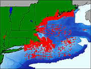
| Description | These data were collected by the National Ocean Service (NOS, formerly the U.S. Coast and Geodetic Survey) for the purpose of charting the coastal waters and navigable waterways of the United States. Data collected prior to 1965 were digitized from the final survey plots. All other data were digitized in the field during the surveys. These data were supplied by the National Geophysical Data Center (NGDC). This data set contains fields that are only a subset of those fields available in the NOS Hydrographic Database, but included in this data set are the NOS cartographic codes for bottom characteristics. Although included here, these codes are no longer customarily supplied by NGDC with the NOS Hydrographic Database. As such, this data layer provides important information that is no longer readily available. [More] |
| Originators | Poppe, Lawrence J.; Paskevich, Valerie F.; Williams, S. Jeffress; Hastings, Mary E.; Kelley, John T.; Belknap, D. F.; Ward, Larry G.; Fitzgerald, D. M.; and Larsen, Peter F. |
