Bathymetry, backscatter intensity, seismic reflection, and benthic habitat data offshore of Arcata, California
By Guy R. Cochrane
https://doi.org/10.5066/P9J1K4QX
Dates
Published: March 25, 2024
Summary
Survey data collected for this data release were used to create maps of surficial geology and benthic habitat as part of the USGS California Seafloor Mapping Program, a collaboration with California State University Monterey Bay (CSUMB) and the National Oceanic and Atmospheric Administration (NOAA). Funding was provided by the California Ocean Protection Council. These data are intended to provide regional bathymetric information in California State waters for offshore resource and ecosystem management. This data release is part of USGS Data Series 781 (Golden and Cochrane, 2019), which can be found at https://doi.org/10.3133/ds781. This part of the Data Series includes substrate, geomorphic, and geologic attributed polygons in the Offshore of Arcata, California, map area, one of 83 map areas of the California State Waters Map Series. The polygons are derived from multibeam echosounder (MBES) data and derivatives of that data using video-supervised and unsupervised classification. Habitat attributes are named following the Coastal and Marine Ecological Classification Standard (Federal Geographic Data Committee, 2012), and attribute values conform to that standard in order to be useful for national ecosystems management. This release also includes an estimate of sediment thickness above the transgressive surface derived from mini-sparker seismic reflection data.
Geology Data
-
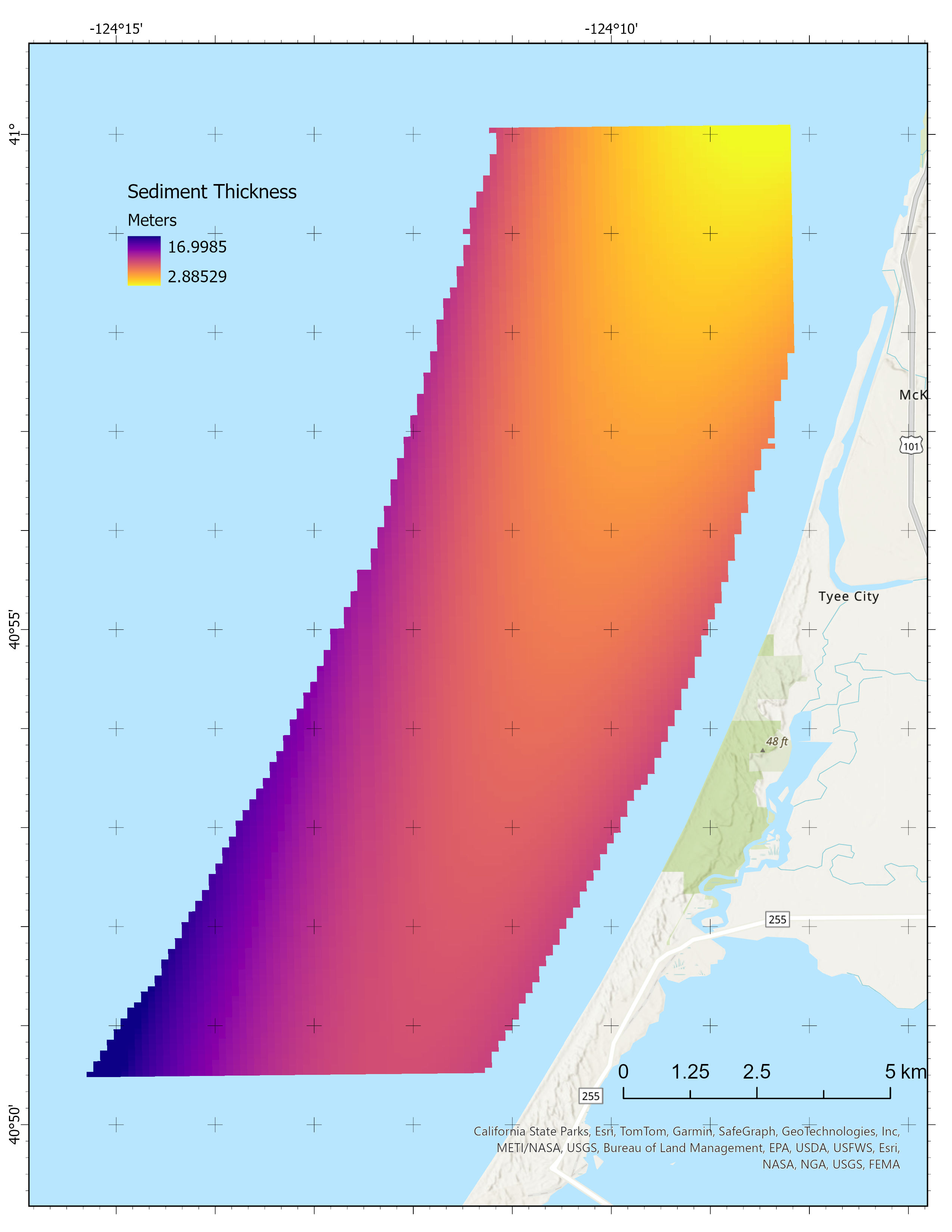
Sediment thickness from seismic reflection data collected offshore of Arcata, California
This 100-m-resolution sediment thickness data raster for the Offshore of Arcata, California, map area is part of USGS Data Series 781 (Golden and Cochrane, 2019). Seismic data were collected by the USGS in 2009 using a mini-sparker seismic systems installed on the Humboldt State University R/V Coral Sea. The data were processed by the USGS into segy format files. The data are available as a georeferenced TIFF image.
Data Files
SedimentThickness_OffshoreArcata.zip - 47.4 KB
Metadata Files
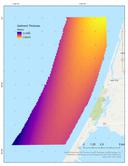 Preview image of sediment thickness offshore of Arcata
Habitat Data
-
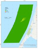
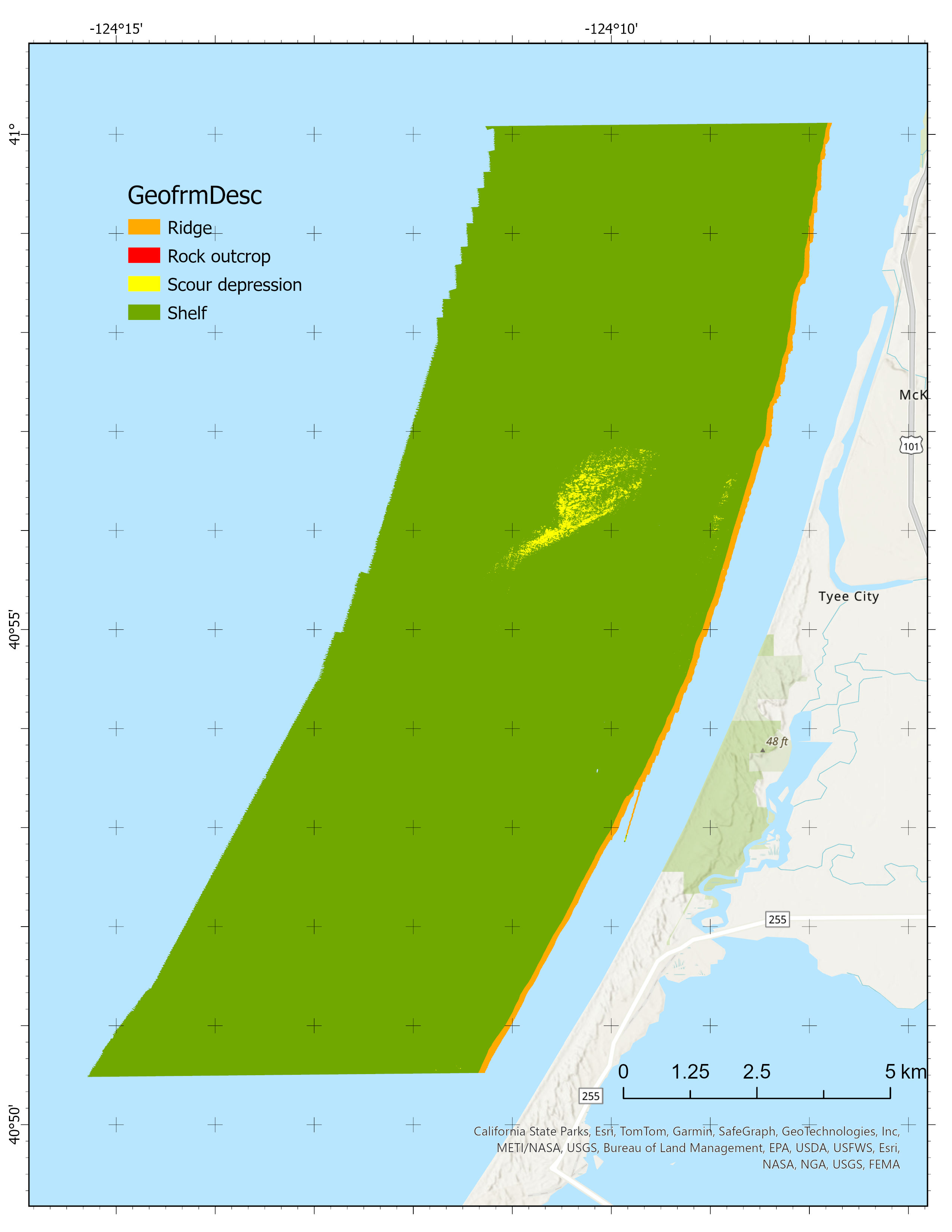
CMECS geoform, CMECS substrate, and surficial geology offshore of Arcata, California
This substrate, geomorphic, and geologic attributed polygon shapefile in the Offshore of Arcata, California, map area is part of USGS Data Series 781 (Golden and Cochrane, 2019). The map area is one of 83 map areas of the California State Waters Map Series. The polygons are derived from multibeam echosounder (MBES) data and derivatives of that data using video-supervised and unsupervised classification. Attributes and attribute values are named following the Coastal and Marine Ecological Classification Standard (CMECS; Federal Geographic Data Committee, 2012) to be useful for ecosystems management.
Data Files
CMECS_OffshoreArcata.zip - 379.9 KB
Metadata Files
CMECS_OffshoreArcata_metadata.xml - 29.8 KB
CMECS_OffshoreArcata_metadata.txt - 31.1 KB
 Preview image of CMECS benthic habitat offshore of Arcata
 -
Seafloor character offshore of Arcata, California
This seafloor character raster for the Offshore of Arcata, California, map area is part of USGS Data Series 781 (Golden and Cochrane, 2019). Seafloor character is a combination of seafloor induration (surface hardness) and rugosity, was derived from multibeam echosounder (MBES) and annotated underwater video data collected offshore of Arcata, California. The MBES and underwater video data were collected in support of the U.S. Geological Survey (USGS) California Seafloor Mapping Program, under a collaboration with the California State University Monterey Bay Seafloor Mapping Lab, the California Ocean Protection Council, and the National Oceanic and Atmospheric Administration (NOAA). Substrate observations from the underwater video were translated into Coastal and Marine Ecological Classification Standard (CMECS; Federal Geographic Data Committee, 2012) induration classes to use as training for a supervised numerical classification of the MBES data. The seafloor character raster is provided as a 2-meter resolution GeoTIFF.
Data Files
SeafloorCharacter_OffshoreArcata.zip - 182.6 KB
Metadata Files
 Preview image of seafloor character offshore of Arcata

Multibeam Data
-
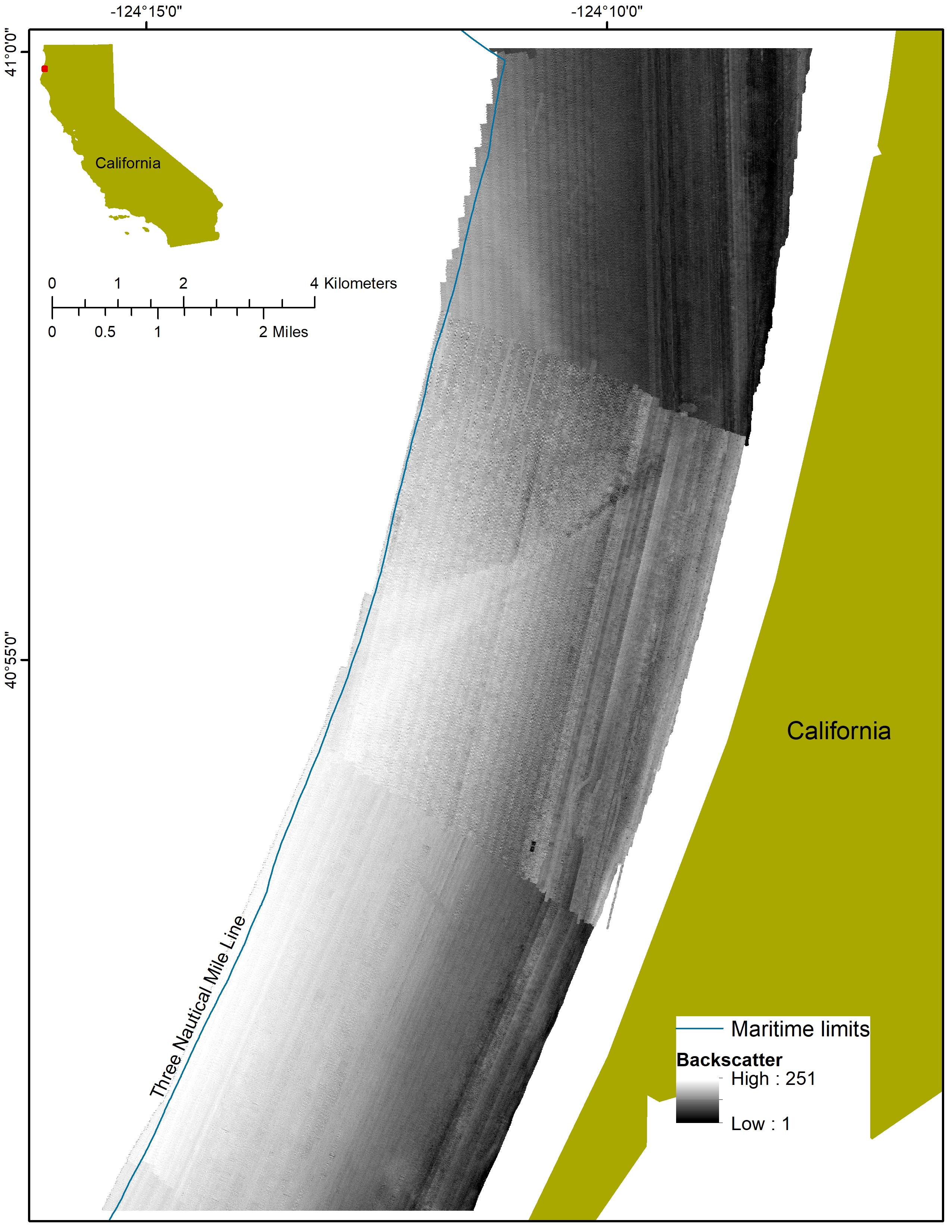
Acoustic backscatter intensity from multibeam echosounder data collected offshore of Arcata, California
This 2-m-resolution acoustic backscatter data for the Offshore of Arcata, California, map area is part of USGS Data Series 781 (Golden and Cochrane, 2019). Backscatter data were collected by Fugro Pelagos in 2007 using a combination of 400-kHz Reson 7125, 240-kHz Reson 8101, and 100-kHz Reson 8111 multibeam echosounder systems. The data were post-processed by the California State University Monterey Bay Seafloor Mapping. The acoustic backscatter data are available as a georeferenced TIFF image. Within the final imagery, brighter tones indicate higher backscatter intensity, and darker tones indicate lower backscatter intensity. The intensity represents a complex interaction between the acoustic pulse and the seafloor, as well as characteristics within the shallow subsurface, providing a general indication of seafloor texture and composition. Backscatter intensity depends on the acoustic source level; the frequency used to image the seafloor; the grazing angle; the composition and character of the seafloor, including grain size, water content, bulk density, and seafloor roughness; and some biological cover. Harder and rougher bottom types such as rocky outcrops or coarse sediment typically return stronger intensities (high backscatter, lighter tones), whereas softer bottom types such as fine sediment return weaker intensities (low backscatter, darker tones).
Data Files
Backscatter_OffshoreArcata.zip - 29.0 MB
Metadata Files
Backscatter_OffshoreArcata_metadata.xml - 17.1 KB
Backscatter_OffshoreArcata_metadata.txt - 16.7 KB
 Preview image of the acoustic-backscatter data offshore of Arcata
 -
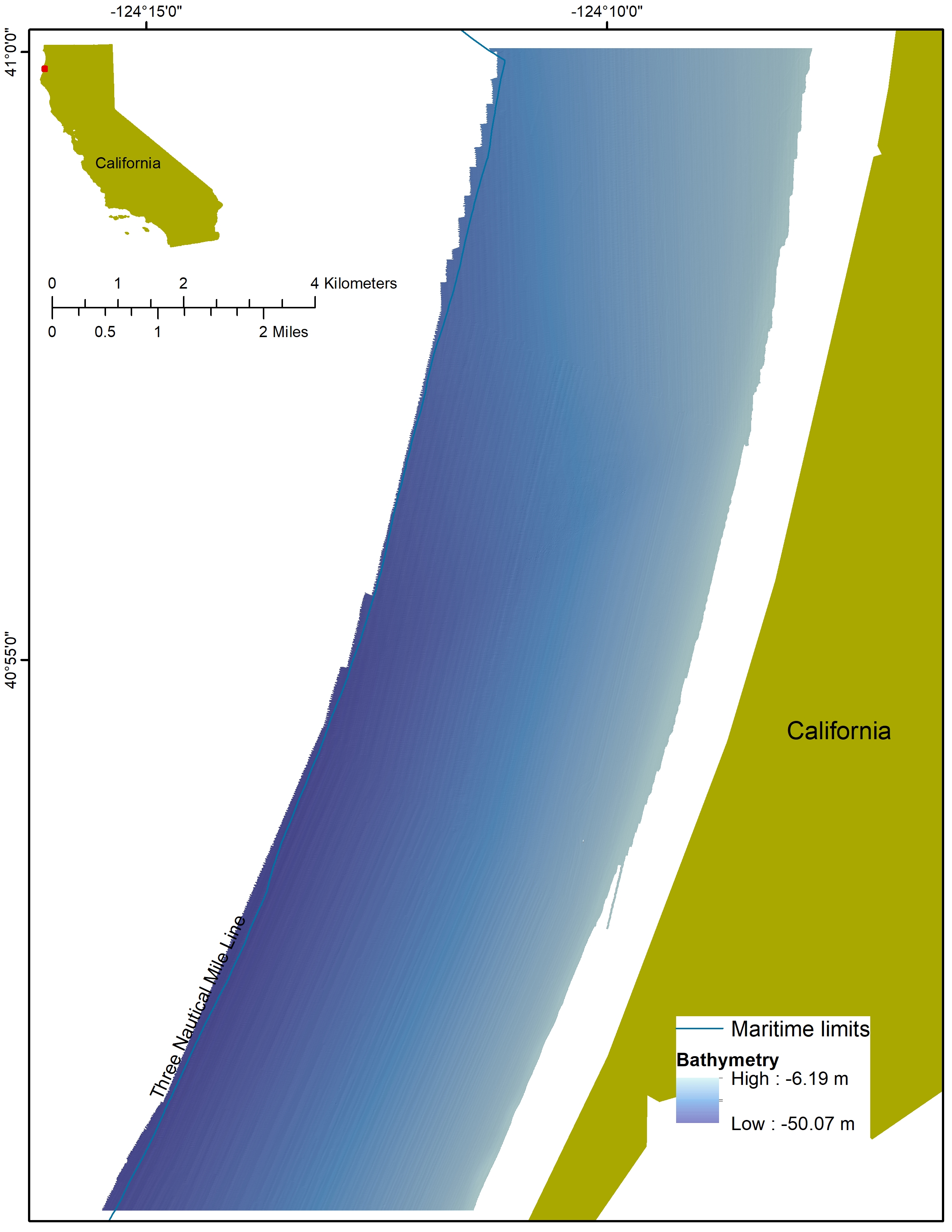
Bathymetry from multibeam echosounder data collected offshore of Arcata, California
This 2-m-resolution bathymetry data for the Offshore of Arcata, California, map area is part of USGS Data Series 781 (Golden and Cochrane, 2019). Bathymetry data were collected by Fugro Pelagos in 2007 using a combination of 400-kHz Reson 7125, 240-kHz Reson 8101, and 100-kHz Reson 8111 multibeam echosounder systems. The data were processed by the California State University Monterey Bay Seafloor Mapping Lab. The bathymetry data are available as a georeferenced TIFF image.
Data Files
Bathymetry_OffshoreArcata.zip - 53.9 MB
Metadata Files
Bathymetry_OffshoreArcata_metadata.xml - 16.5 KB
Bathymetry_OffshoreArcata_metadata.txt - 16.1 KB
 Preview image of bathymetry offshore of Arcata
Sparker Data
-
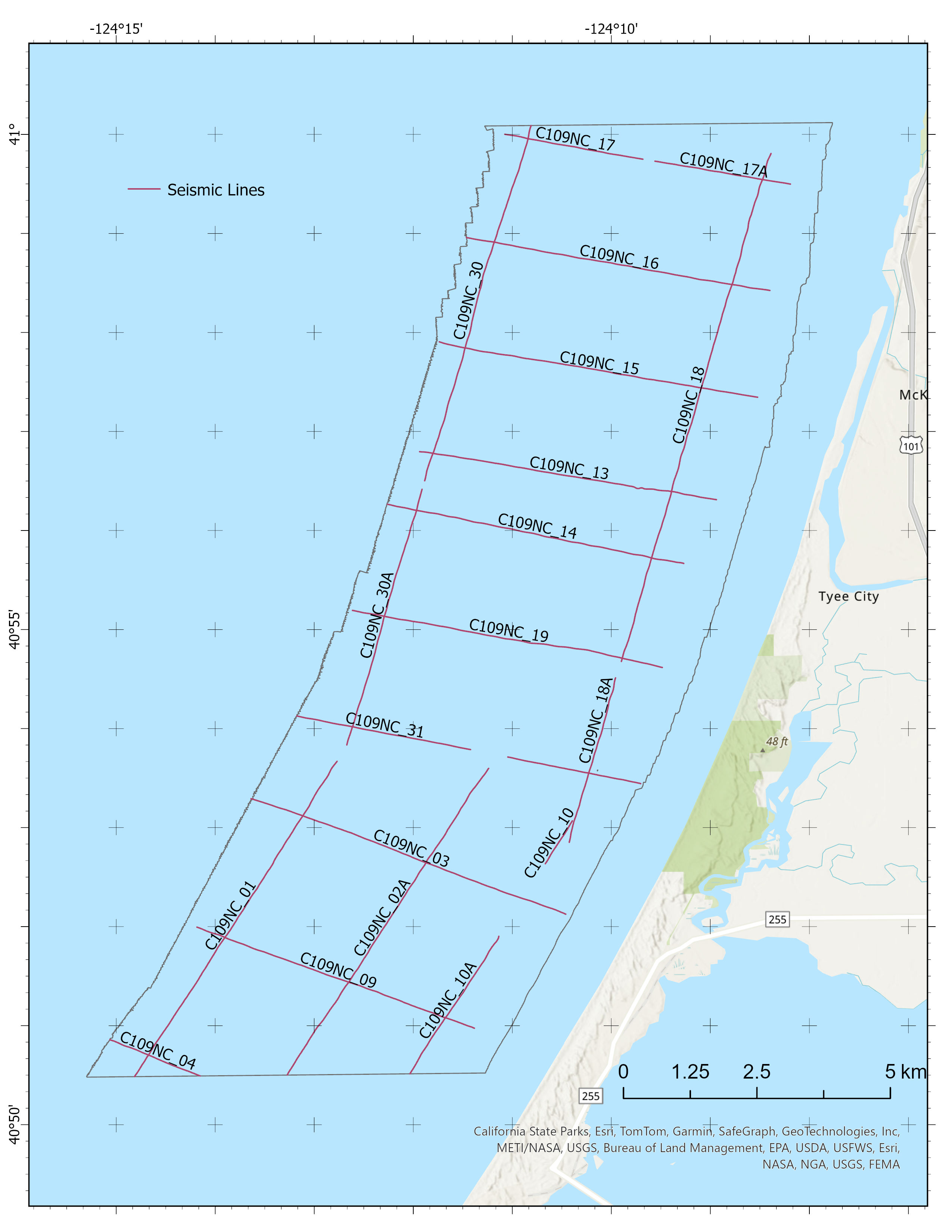
Sparker seismic reflection data collected during USGS field activity C109NC offshore of Arcata
This processed high-resolution sparker seismic-reflection (Seismic) data for the Offshore of Arcata, California, map area is part of USGS Data Series 781 (Golden and Cochrane, 2019). The map area is one of 83 map areas of the California State Waters Map Series. The data were collected aboard Humboldt State Universitys R/V Coral Sea in 2009 on U.S. Geological Survey cruise C109NC on the shelf between Cape Blanco, Oregon, and Cape Mendocino, California. Seismic data were collected to characterize quaternary deformation and sediment dynamics on the continental shelf offshore of Humboldt Bay.
Data Files
SeismicReflection_OffshoreArcata.zip - 785.3 MB
Metadata Files
 Preview image of seismic tracklines offshore of Arcata
Related Field Activities
- C109NC - View Details
Suggested Citation
Cochrane, G.R., 2024, Bathymetry, backscatter intensity, seismic reflection, and benthic habitat offshore of Arcata, California: U.S. Geological Survey data release, https://doi.org/10.5066/P9J1K4QX.