AKA: none
Other ID: CalDIG II
Status: Completed
Organization(s): USGS, Pacific Coastal and Marine Science Center
Funding Program(s): Marine Geomorphology, Evolution, and Habitats (ZP00FE6)
Principal Investigator(s): Guy Cochrane
Affiliate Investigator(s): Charles Paull (MBARI)
Information Specialist(s): Guy Cochrane
Data Type(s): Imagery: Video, Sampling: Geology, Location-Elevation: Navigation, Seismics: Sub Bottom Profiler
Scientific Purpose/Goals: Benthic habitat, structure, and sedimentary processes in support of offshore energy development.
Vehicle(s):
Start Port/Location: San Diego, CA
End Port/Location: San Francisco, CA
Start Date: 2019-09-09
End Date: 2019-09-27
Equipment Used: GPS, 3.5khz, Remotely Operated Vehicle, pistoncore
Information to be Derived: Surficial geology, benthic habitat, grain size, sediment ages, pore water chemistry
Summary of Activity and Data Gathered: Piston and Gravity Coring. Coring was conducted for the most part during daylight hours at the request of the Ship’s Captain. The piston coring rail system was arranged on the fantail at a slight diagonal to allow a line and capstan to be rigged on the starboard deck to pull the corer along rails. Cores were collected on 12 of the 13 days at sea. A total of 41 cores were collected. The ROV dives were impacted more significantly by weather conditions that the coring operations. Objectives had to be achieved by modifying the original site plan. Of the original plan ten of the original sites were surveyed three of which were considered priority 1 sites out of 23 total dives. Video data are archived with MBARI.
Staff: Peter Dal Ferro, Daniel Powers, Maureen Walton
Affiliate Staff:
Notes: Numerous MBARI staff for coring and ROV.
Location:
South Central California
| Boundaries | |||
|---|---|---|---|
| North: 35.84 | South: 34.51 | West: -122.02 | East: -120.91 |
Platform(s):
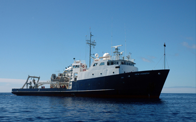 Bold Horizon |
Cochrane, G.R., Kuhnz, L.A., Dartnell, P., Gilbane, L., and Walton, M.A., 2022, Multibeam echosounder, video observation, and derived benthic habitat data offshore of south-central California in support of the Bureau of Ocean Energy Management Cal DIG I, offshore alternative energy project: U.S. Geological Survey data release, https://doi.org/10.5066/P9QQZ27U.
Kennedy, D.J., Walton, M.A., Cochrane, G.R., Addison, J.A., Paull, C.K., Gwiazda, R., Lorenson, T.D., and Lundsten, E., 2021, Piston and gravity core data collected during USGS cruise 2019-642-FA offshore of south-central California in support of the Bureau of Ocean Energy Management (BOEM) California Deepwater Investigations and Groundtruthing (Cal DIG I) alternative energy project, September 2019: U.S. Geological Survey data release, https://doi.org/10.5066/P9DE639J.
McGann, M., Paull, C.K., Lundsten, E., Gwiazda, R., Walton, M.A.L., Nieminski, N.M., Lorenson, T.D., and Lee. H.J, 2023, Radiocarbon age dating of biological material from cores collected off central California in 1999, 2006, and 2019: U.S. Geological Survey data release, https://doi.org/10.5066/P9FWTKZQ.
| Survey Equipment | Survey Info | Data Type(s) | Data Collected |
|---|---|---|---|
| GPS | --- | Navigation | |
| 3.5khz | --- | Sub Bottom Profiler | |
| Remotely Operated Vehicle | --- | Photo Video Biology Chemistry Geology | Biotic observations derived from underwater video (Physical, environmental, and biotic observations were derived from underwater video collected by the Monterey Bay Aquarium Research Institute (MBARI) using remotely operated vehicles (ROVs) offshore of Morro Bay, California. The data were acquired during three separate surveys in 2019 in support of the U.S. Geological Survey (USGS)/Bureau of Ocean Energy Management (BOEM) California Deepwater Investigations and Groundtruthing I (Cal DIG I) project.) Substrate observations derived from underwater video (Physical, environmental, and substrate observations were derived from underwater video collected by the Monterey Bay Aquarium Research Institute (MBARI) using remotely operated vehicles (ROVs) offshore of Morro Bay, California. A majority of the data were acquired during three separate surveys in 2019 in support of the U.S. Geological Survey (USGS)/Bureau of Ocean Energy Management (BOEM) California Deepwater Investigations and Groundtruthing I (Cal DIG I) project.) |
| pistoncore | --- | Geology | Photographs of piston and gravity cores (This dataset includes photographs of 39 piston and gravity cores that were collected as part of a groundtruthing survey in September 2019 aboard the R/V Bold Horizon. This dataset is one of several collected as part of the Bureau of Ocean Energy Management (BOEM)-funded California Deepwater Investigations and Groundtruthing (Cal DIG I) project.) Multi-Sensor Core Logger (MSCL) data of piston and gravity cores (This dataset includes multi-sensor core logger (MSCL) data for 39 piston and gravity cores that were collected as part of a groundtruthing survey in September 2019 aboard the R/V Bold Horizon. This dataset is one of several collected as part of the Bureau of Ocean Energy Management (BOEM)-funded California Deepwater Investigations and Groundtruthing (Cal DIG I) project.) Location and depth data for piston and gravity cores (This dataset includes the location and depth information for 39 piston and gravity cores that were collected as part of a groundtruthing survey in September 2019 aboard the R/V Bold Horizon. This dataset is one of several collected as part of the Bureau of Ocean Energy Management (BOEM)-funded California Deepwater Investigations and Groundtruthing (Cal DIG I) project.) Porewater chloride and sulfate concentrations from piston and gravity cores (This dataset includes concentrations chloride and sulfate in porewater from piston and gravity cores collected in September 2019 offshore of south-central California aboard the R/V Bold Horizon. This dataset is one of several collected as part of the Bureau of Ocean Energy Management (BOEM)-funded California Deepwater Investigations and Groundtruthing (Cal DIG I) project.) |
