Imagery Data System
The image displayed on this page is a thumbnail, please use the download function to obtain the full-resolution image.
Filename: 2023022FA_PXL_20230913T191003Z.jpg
This image is part of the data release:
Topographic data, imagery, and ground control data collected in September 2023 pre and post Hurricane Lee at Head of the Meadow, Marconi, and Nauset Light beaches, Cape Cod National Seashore, Massachusetts
Image data:
Keywords:
Cape cod national seashore
Collection:
2023_NLB_context
Field activity number:
2023-022-FA:
More images from FAN |
CMGDS details
Topic: Geology, Mapping, Remote Sensing, and Geospatial DataPurpose: Field activityClass: Structure-from-Motion, OperationsSubject: beachSemantic Location: Nauset, Cape Cod, MassachusettsPeople:
No people visible in image
FAN : Public: TrueFile Size: 1301737 bytesUploaded By: sackermanUploaded At: Nov. 21, 2023, 4:48 p.m. (UTC)
Imagery header data:
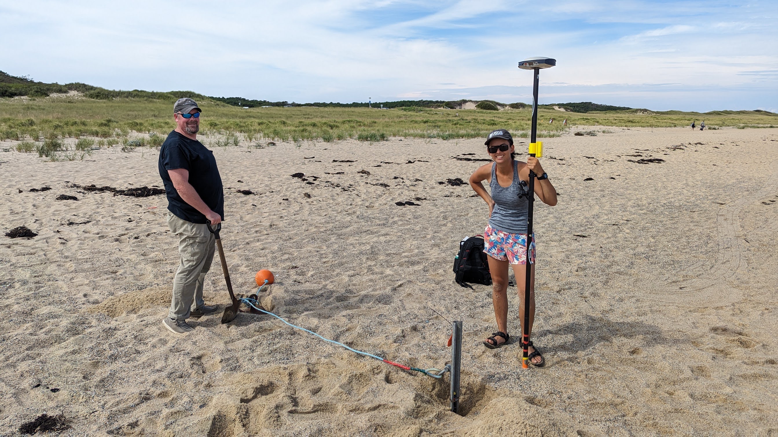
Credit: U.S. Geological SurveyContact: WHSC_data_contact@usgs.govCopyright: Public DomainImage Description: https://cmgds.marine.usgs.gov/fan_info.php?fan=2023-022-FA; Eric Marsjanik and Jin-Si Over standing beside the installed pressure sensor at Head of the Meadow Beach, an 8 ft fence post was driven into the sand and a bouy and anchor were attached.Attribution URL: https://doi.org/10.5066/P9GA5RJD GPS Latitude: 42.0521233799897GPS Latitude Reference: NGPS Longitude: -70.0778530600861GPS Longitude Reference: WGPS Time Stamp (UTC): 16:10:03Date/Time Original: 2023-09-13 11:10:03Date/Time Modified: 2023-09-13 11:10:03PID (Image Unique ID): b984c73d4f9aceb50000000000000000Artist: Christopher SherwoodPreserved Filename: PXL_20230913_151003971.jpgExternal Metadata Link: https://www1.usgs/gov/pir/api/identifiers/USGS:6511a3bdd34e823a0275dbdf Camera Make: GoogleCamera Model: Pixel 6