| Identifier | 2018-652-FA | ||||||||
|---|---|---|---|---|---|---|---|---|---|
| Purpose | Collect bathymetric and topographic data from Oregon and Washington coasts. | ||||||||
| Location | Oregon and Washington Coast | ||||||||
| Summary | bathy, linefiles, matlab, photos, planning and svp on FAD; 8/20/2018; from nearshore_bathy/crlc) | ||||||||
| Info derived | Beach Topography, Nearshore Bathymetry | ||||||||
| Comments | Entries for this field activity are based on entries from Field Activity 2014-631-FA Entries for this field activity are based on entries from Field Activity 2015-647-FA Entries for this field activity are based on entries from Field Activity 2016-663-FA Entries for this field activity are based on entries from Field Activity 2017-666-FA | ||||||||
| Projects | |||||||||
| Platform |
|
||||||||
| Vehicles | MarFac; Chevy Suburban - gray; 7 pass; G62-2874L |
||||||||
| Itinerary |
|
||||||||
| Bounds |
|
| Organization |
2885 Mission Street
Santa Cruz, CA95060
(831) 460-7401
|
||||||
|---|---|---|---|---|---|---|---|
| Principal investigators | Andrew Stevens | ||||||
| Crew members |
|
||||||
| Information specialist(s) |
|
||||||
| Affiliate principal | Peter Ruggiero (Oregon State) George Kaminsky (WA Dept. of Ecology) |
| Data category: | Imagery, Location-Elevation, Sonar |
|---|---|
| Data type: | Photo, Benchmarks, Navigation, Profiles, Transects, Single Beam, Sound Velocity |
| Equipment | Usage description | Data types | Datasets |
|---|---|---|---|
| Radio (base) | Benchmarks, LIDAR, Navigation, Profiles, Transects | (no data reported) | |
| Radio (rover) | Navigation, Profiles, Transects | (no data reported) | |
| Trimble R10 GPS (AS) | Navigation, Profiles | (no data reported) | |
| Trimble R7 GPS (AS) | Benchmarks, Navigation, Profiles, Transects | (no data reported) | |
| Trimble R7 GPS receiver | Benchmarks, LIDAR, Navigation, Profiles, Transects | 1 | |
| Trimble R7 GPS receiver 9 | Benchmarks, LIDAR, Navigation, Profiles, Transects | (no data reported) | |
| Echosounder-1 (Odom Echotrac CV-100) | Single Beam | (no data reported) | |
| Echosounder-2 (Odom Echotrac CV-100) | Single Beam | 1 | |
| camera | Photo | (no data reported) | |
| YSI Sound velocity CTD | Depth, Temperature, Current, Mooring (physical oceanography), Sound Velocity | (no data reported) |
| Dataset name | Equipment | Description | Dataset contact |
|---|---|---|---|
| Beach topography of the Columbia River littoral cell, Washington and Oregon, 2018 | Trimble R7 GPS receiver | This portion of the USGS data release presents topography data collected during surveys performed in the Columbia River littoral cell, Washington and Oregon, in 2018 (USGS Field Activity Number 2018-652-FA). Topographic profiles were collected by walking along survey lines with global navigation satellite system (GNSS) receivers mounted on backpacks. | |
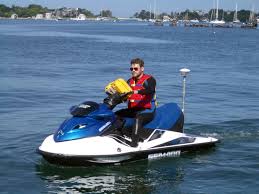
| Nearshore bathymetry of the Columbia River littoral cell, Washington and Oregon, 2018 | Echosounder-2 (Odom Echotrac CV-100) | This portion of the USGS data release presents bathymetry data collected during surveys performed in the Columbia River littoral cell, Washington and Oregon in 2018 (USGS Field Activity Number 2018-652-FA). Bathymetry data were collected using four personal watercraft (PWCs) equipped with single-beam sonar systems and global navigation satellite system (GNSS) receivers. | Andrew Stevens |