Identifier | 2022-604-FA | ||||||||
---|---|---|---|---|---|---|---|---|---|
Alternate names | Winter bathymetric survey, Jenkinson Lake, CA | ||||||||
Purpose | Conduct baseline bathymetric survey of Jenkinson Lake for change detection work in response to Caldor fire in northern California | ||||||||
Location | Northern CA | ||||||||
Summary | 
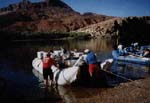
Swath mapping of Jenkinson Lake was conducted using the R/V San Lorenzo 2022-01-10 - 2022-01-12. Single-beam mapping was conducted in the shallow upper portion of the lake using the CEEscope echosounder on a rigid-hull inflatable boat 2022-01-11 - 2022-01-12. Average daily lake levels recorded by El Dorado Irrigation District were approximately 3,448 ft (98 ft level), 67% of full. Area of bathymetric data collection on the reservoir delta at Hazel Creek and Sly Park Creek overlapped considerably with the lateral extent of the topographic UAS surveys conducted on 2021-10-13 (FAN 2021-655-FA) and 2021-11-04 (FAN 2021-659-FA), during which the water surface elevation was lower. | ||||||||
Info derived | bathymetry | ||||||||
Comments | Entries for this field activity are based on entries from Field Activity 2021-659-FA. | ||||||||
Projects | |||||||||
Platform |
|
||||||||
Itinerary |
|
||||||||
Bounds |
|
Organization |
2885 Mission Street
Santa Cruz, CA95060
(831) 460-7401
|
||||||||
---|---|---|---|---|---|---|---|---|---|
Principal investigators | Amy East | ||||||||
Crew members |
|
||||||||
Information specialist(s) |
|
Data category: | Sonar, Location-Elevation |
---|---|
Data type: | Interferometric, Single Beam, Navigation |
Equipment | Usage description | Data types | Datasets |
---|---|---|---|
GPS | Navigation | (no data reported) | |
Fathometer | Single Beam | (no data reported) | |
Interferrometric | Interferometric | 2 |
Dataset name | Equipment | Description | Dataset contact |
---|---|---|---|
Acoustic-backscatter data for Jenkinson Lake, California collected during USGS field activity 2022-604-FA | Interferrometric | Here January 2022 1-m resolution acoustic-backscatter data are provided for Jenkinson Lake, California. Acoustic-backscatter data were collected during three separate SWATHPlus surveys of Jenkinson Lake. | Peter Dartnell |
Dataset name | Equipment | Description | Dataset contact |
---|---|---|---|
Bathymetry data for Jenkinson Lake, California collected during USGS field activity 2022-604-FA | Interferrometric | Here January 2022 1-m resolution bathymetry data of Jenkinson Lake, California are provided for the entire lake and 0.5-m resolution bathymetry data are provided for the shallower upper basin. Bathymetry data were collected during three separate SWATHPlus surveys of Jenkinson Lake. | Peter Dartnell |
Dartnell,P; East, A.E; Logan, J; Hatcher G.A; Currie, J.E; Marcuson, R.K; Powers, D.C; Dal Ferro, P; and McKee, J.A., 2024, Bathymetry and Acoustic Backscatter data for Jenkinson Lake, California collected during three USGS field activities, 2022-604-FA, 2022-649-FA, and 2023-634-FA: , https://doi.org/10.5066/P13BSSDY.