| Digital elevation models (DEMs) of the Elwha River delta, Washington, July and August 2023 |
Trimble R7 GPS (AS) |
Digital elevation models (DEMs) of the Elwha River delta were constructed from bathymetric and topographic surveys collected in July and August 2023. Nearshore bathymetry data were acquired using two personal watercraft (PWCs) and a kayak equipped with single-beam echosounders and survey-grade global navigation satellite systems (GNSS) receivers. Topographic data were collected on foot with survey-grade GNSS receivers mounted on backpacks. A total of 1,301,196 individual elevation points were collected between July 30 and August 2, 2023, and used to create DEM surfaces with linear interpolation. A DEM was generated for the entire Elwha River delta with a resolution of 5 m and another DEM that included the river mouth region had a resolution of 1 m. |
Andrew Stevens |
| Topography data from the Elwha River delta, Washington, July and August 2023 |
Trimble R7 GPS (AS) |
This part of the data release presents topography data from the Elwha River delta collected in July and August 2023. Topography data were collected on foot with global navigation satellite system (GNSS) receivers mounted on backpacks. |
Andrew Stevens |
| Digital elevation models (DEMs) of the Elwha River delta, Washington, July and August 2023 |
Trimble R7 GPS receiver |
Digital elevation models (DEMs) of the Elwha River delta were constructed from bathymetric and topographic surveys collected in July and August 2023. Nearshore bathymetry data were acquired using two personal watercraft (PWCs) and a kayak equipped with single-beam echosounders and survey-grade global navigation satellite systems (GNSS) receivers. Topographic data were collected on foot with survey-grade GNSS receivers mounted on backpacks. A total of 1,301,196 individual elevation points were collected between July 30 and August 2, 2023, and used to create DEM surfaces with linear interpolation. A DEM was generated for the entire Elwha River delta with a resolution of 5 m and another DEM that included the river mouth region had a resolution of 1 m. |
Andrew Stevens |
| Topography data from the Elwha River delta, Washington, July and August 2023 |
Trimble R7 GPS receiver |
This part of the data release presents topography data from the Elwha River delta collected in July and August 2023. Topography data were collected on foot with global navigation satellite system (GNSS) receivers mounted on backpacks. |
Andrew Stevens |
| Digital elevation models (DEMs) of the Elwha River delta, Washington, July and August 2023 |
Trimble R7 GPS receiver 9 |
Digital elevation models (DEMs) of the Elwha River delta were constructed from bathymetric and topographic surveys collected in July and August 2023. Nearshore bathymetry data were acquired using two personal watercraft (PWCs) and a kayak equipped with single-beam echosounders and survey-grade global navigation satellite systems (GNSS) receivers. Topographic data were collected on foot with survey-grade GNSS receivers mounted on backpacks. A total of 1,301,196 individual elevation points were collected between July 30 and August 2, 2023, and used to create DEM surfaces with linear interpolation. A DEM was generated for the entire Elwha River delta with a resolution of 5 m and another DEM that included the river mouth region had a resolution of 1 m. |
Andrew Stevens |
| Topography data from the Elwha River delta, Washington, July and August 2023 |
Trimble R7 GPS receiver 9 |
This part of the data release presents topography data from the Elwha River delta collected in July and August 2023. Topography data were collected on foot with global navigation satellite system (GNSS) receivers mounted on backpacks. |
Andrew Stevens |
| Digital elevation models (DEMs) of the Elwha River delta, Washington, July and August 2023 |
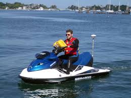
Waverunners |
Digital elevation models (DEMs) of the Elwha River delta were constructed from bathymetric and topographic surveys collected in July and August 2023. Nearshore bathymetry data were acquired using two personal watercraft (PWCs) and a kayak equipped with single-beam echosounders and survey-grade global navigation satellite systems (GNSS) receivers. Topographic data were collected on foot with survey-grade GNSS receivers mounted on backpacks. A total of 1,301,196 individual elevation points were collected between July 30 and August 2, 2023, and used to create DEM surfaces with linear interpolation. A DEM was generated for the entire Elwha River delta with a resolution of 5 m and another DEM that included the river mouth region had a resolution of 1 m. |
Andrew Stevens |
| Nearshore bathymetry data from the Elwha River delta, Washington, July August 2023 |
Waverunners |
Bathymetric data were collected during surveys performed on the Elwha River delta, Washington in 2023 (USGS Field Activity Number 2023-645-FA). Bathymetric data were collected using personal watercraft (PWCs) and a kayak equipped with single-beam sonar systems and global navigation satellite system (GNSS) receivers. |
Andrew Stevens |
| Digital elevation models (DEMs) of the Elwha River delta, Washington, July and August 2023 |
YSI Sound velocity CTD |
Digital elevation models (DEMs) of the Elwha River delta were constructed from bathymetric and topographic surveys collected in July and August 2023. Nearshore bathymetry data were acquired using two personal watercraft (PWCs) and a kayak equipped with single-beam echosounders and survey-grade global navigation satellite systems (GNSS) receivers. Topographic data were collected on foot with survey-grade GNSS receivers mounted on backpacks. A total of 1,301,196 individual elevation points were collected between July 30 and August 2, 2023, and used to create DEM surfaces with linear interpolation. A DEM was generated for the entire Elwha River delta with a resolution of 5 m and another DEM that included the river mouth region had a resolution of 1 m. |
Andrew Stevens |
| Nearshore bathymetry data from the Elwha River delta, Washington, July August 2023 |
YSI Sound velocity CTD |
Bathymetric data were collected during surveys performed on the Elwha River delta, Washington in 2023 (USGS Field Activity Number 2023-645-FA). Bathymetric data were collected using personal watercraft (PWCs) and a kayak equipped with single-beam sonar systems and global navigation satellite system (GNSS) receivers. |
Andrew Stevens |