| Nearshore bathymetry of Humboldt Bay North Spit and South Spit, California |
Trimble R10 |
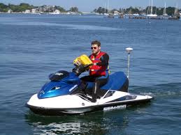
Bathymetric data of the nearshore zone were collected along Humboldt Bay North and South Spits, California using personal watercraft (PWCs) equipped with single-beam sonar systems and global navigation satellite system (GNSS) receivers. This data release currently contains bathymetric data from 2 surveys performed between April 2025 and September 2025 and will be updated when additional surveys become available. |
Andrew Stevens |
| Beach topography of Humboldt Bay North Spit and South Spit, California |
RTK GPS |
Topographic data were collected along the beaches and dunes of Humboldt Bay North Spit and South Spit, California using global navigation satellite system (GNSS) receivers mounted to backpacks. Additional topographic data were collected between transects in some areas with an all-terrain vehicles equipped with GNSS receivers. This data release currently contains topographic data from 2 surveys performed between April 2025 and September 2025 and will be updated when additional surveys become available. |
Andrew Stevens |
| Beach topography of Humboldt Bay North Spit and South Spit, California |
Base - Trimble |
Topographic data were collected along the beaches and dunes of Humboldt Bay North Spit and South Spit, California using global navigation satellite system (GNSS) receivers mounted to backpacks. Additional topographic data were collected between transects in some areas with an all-terrain vehicles equipped with GNSS receivers. This data release currently contains topographic data from 2 surveys performed between April 2025 and September 2025 and will be updated when additional surveys become available. |
Andrew Stevens |
| Nearshore bathymetry of Humboldt Bay North Spit and South Spit, California |
Cee HydroSystems Ceescope |
Bathymetric data of the nearshore zone were collected along Humboldt Bay North and South Spits, California using personal watercraft (PWCs) equipped with single-beam sonar systems and global navigation satellite system (GNSS) receivers. This data release currently contains bathymetric data from 2 surveys performed between April 2025 and September 2025 and will be updated when additional surveys become available. |
Andrew Stevens |