| Identifier | 96CCT01 | ||||||||
|---|---|---|---|---|---|---|---|---|---|
| Alternate names | G-1-96-SR | ||||||||
| Purpose | Geologic framework and coastal processes study | ||||||||
| Location | Charleston, SC, South Carolina | ||||||||
| Summary | Boomer (34 lines), sidescan, vibracore. | ||||||||
| Info derived | Geophysical data | ||||||||
| Comments | Coastal Change and Transport. These FACS logs were generated by Karynna Calderon in February of 2003 using the handwritten logbooks and personal accounts of the crew members. | ||||||||
| Projects | |||||||||
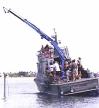
| Platform |
|
||||||||
| Itinerary |
|
||||||||
| Bounds |
|
| Organization |
600 Fourth Street South
St. Petersburg, FL33701-4846
(727) 502-8000
|
|---|---|
| Principal investigators | Jack L Kindinger |
| Crew members |
| Data category: | Location-Elevation, Sampling, Seismics, Sonar |
|---|---|
| Data type: | Navigation, Geology, Boomer, Sidescan, Single Beam |
| Equipment | Usage description | Data types | Datasets |
|---|---|---|---|
| Global Positioning System (GPS) | Navigation | 1 | |
| Vibracorer | Geology | (no data reported) | |
| Huntec ESU-PSU | Boomer, Sub Bottom Profiler | (no data reported) | |
| Single-beam Acoustic Sounder | Single Beam | (no data reported) | |
| Sidescan Sonar | Sidescan | (no data reported) | |
| ITI ST-5 Hydrophone Streamer | Air Gun / Water Gun, Boomer, Sparker | 1 |
| Dataset name | Equipment | Description | Dataset contact |
|---|---|---|---|
| Nav data | Global Positioning System (GPS) | Jack L Kindinger | |
| Boomer seismic data | ITI ST-5 Hydrophone Streamer | James G Flocks |