| Identifier |
2018-651-FA |
| Purpose |
Determine controls on sediment transport from the fore reef to the shoreline. |
| Location |
South Molokai, Hawaii |
| Summary |
Mooring data submitted to FAD by Josh Logan 12/19/2018; archived under FAN 2018-617-FA. |
| Info derived |
tide, wave height, wave period, wave direction, current speed, current direction, optical backscatter, acoustic backscatter, imagery. |
| Comments |
Entries for this field activity are based on entries from Field Activity 2018-617-FA |
| Projects |
|
| Platform |
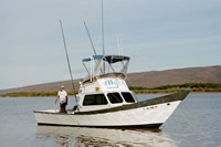
| Alyce C 28-ft-long
|
 |
|
| Vehicles |
|
| Itinerary |
| Start |
Kaunakakai, Molokai, HI |
2018-09-17 |
| End |
Kaunakakai, Molokai, HI |
2018-09-26 |
| Days in the field |
8 |
|
| Bounds |
| West |
-157.19755503 |
| East |
-157.12607593 |
| North |
21.10437892 |
| South |
21.06947819 |
Leaflet | Tiles © Esri — Source: Esri, Garmin, GEBCO, NOAA NGDC, i-cubed, USDA, USGS, AEX, GeoEye, Getmapping, Aerogrid, IGN, IGP, UPR-EGP, and the GIS User Community, Tiles courtesy of the U.S. Geological Survey |
| Scuba operations |
Yes |