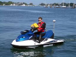
Field Activity 2024-614-FA

Identifier 2024-614-FA
Alternate names San Lorenzo River Mouth
Purpose Collect nearshore bathymetry and beach topography in Monterey Bay
Location Monterey Bay
Summary Beach topography and nearshore bathymetry data collected and archived.
Info derived Nearshore bathymetry, beach topography
Comments Local Fieldwork, Entries for this field activity are based on entries from Field Activity 2023-627-FA.
Projects
Platform
Waverunner 1 (SC)
Personal Water Craft
Waverunner 2 (SC)
Personal Water Craft
Vehicles
Explorer G62-2733K
MarFac; Chevy Suburban - gray; 7 pass; G62-2874L
Itinerary
Start Santa Cruz, CA 2024-03-07
End Santa Cruz, CA 2024-03-08
Days in the field 2
Bounds
West -122.0450592
East -121.95922852
North 36.97238683
South 36.92354768
Marine operations Yes

Personnel

Organization
2885 Mission Street
Santa Cruz, CA95060
(831) 460-7401
Principal investigators Jonathan WarrickPatrick BarnardAmy East
Crew members
Andrew Stevens
Scientist, Staff
Joshua Logan
Scientist, Staff
Alexander G Snyder
Scientist, Staff
Parker, Kai
Scientist, Staff
Nereson, Alexander
Scientist, Staff
Anita C Engelstad
Scientist, Staff
Information specialist(s)
Alexander G Snyder
Specialist, Information

Data types and categories

Data category: Imagery, Location-Elevation, Sonar
Data type: Photo, Navigation, Profiles, Single Beam, Sound Velocity

Equipment used

Equipment Usage description Data types Datasets
camera Photo (no data reported)
Magellan Proflex 500 Navigation (no data reported)
Trimble R10 GPS (AS) Navigation, Profiles (no data reported)
Trimble R7 GPS (AS) Benchmarks, Navigation, Profiles, Transects (no data reported)
Trimble R7 GPS receiver Benchmarks, LIDAR, Navigation, Profiles, Transects (no data reported)
Trimble R7 GPS receiver 9 Benchmarks, LIDAR, Navigation, Profiles, Transects (no data reported)
Waverunners Navigation, Single Beam (no data reported)
YSI Sound velocity CTD Sound Velocity (no data reported)

Publications

Samples collected during this field activity