Six AUV dives planned in the California Borderland, located offshore between Newport, CA and San Mateo Point. Three primary targets: 1) Deformed sediments over the San Mateo Thrust west of San Mateo Point; 2) Palos Verdes Fault Zone/ San Gabriel Canyon west of Newport; 3) area near Coronado Bank Fault zone, faulted strata and possible hydrate target. The areas mapped are in water depths of 250 to 850 m. The primary objective of these dives is to obtain multibeam bathymetric data and high-resolution subbottom profiles. Processing and analysis of this data will be used to identify target sites for core sampling related to active faulting in order to determine the time of the most recent fault movement and for sedimentary architecture related to methane gas discharge and hydrate formation.
Description
Monterey Bay Aquarium Research Institute,United States Geological Survey, Menlo Park, California. Chirp and Multibeam Sonar data of field activity Z-2-07-SC in Offshore Orange County, CA from 07/09/2007 to 07/16/2007
Location
CA
Summary
Local times used; (July 9 JD 190) ~1700/JD190 R/V Zephyr departs Moss Landing. ~2100/JD191 R/V Zephyr arrives Ocean Institute, Dana Point. ~1534/JD192 Begin first AUV dive off of San Mateo Point ~1756/JD192 Abort first AUV dive off of San Mateo Point ~2137/JD192 Begin second AUV dive off of San Mateo Point ~0651/JD193 End second AUV dive off of San Mateo Point ~1241/JD193 Begin third AUV dive off of San Mateo Point ~2123/JD193 End third AUV dive off of San Mateo Point ~0354/JD194 Begin first AUV dive over Palos Verdes Fault ~1232/JD194 End first AUV dive over Palos Verdes Fault ~1832/JD194 Begin second AUV dive over Palos Verdes Fault ~0330/JD195 End second AUV dive over Palos Verdes Fault ~1328/JD195 Begin first AUV dive over suspected methane hydrate occurrences ~2227/JD195 End first AUV dive over suspected methane hydrate occurrences ~0345/JD196 Begin second AUV dive over suspected methane hydrate occurrences ~1245/JD196 End second AUV dive over suspected methane hydrate occurrences ~1500/JD196 R/V Zephyr returns Ocean Institute, Dana Point. ~1530/JD196 R/V Zephyr departs Ocean Institute, Dana Point. ~1900/JD197 R/V Zephyr arrives in Moss Landing A total of 6 AUV dives were successful and one was aborted. The first dive was aborted because the AUV was erroneously programmed to ascend for a GPS fix after every line. The AUVs starting position was determined by GPS at the launch site. The vehicle then dives in a USBL-nav-aided spiral to 50 meters above the seafloor. The AUV can survey with the multibeam sounding system and chirp sonar for ~9 hours; it then returns to the sea surface to be picked by the R/V Zephyr. All three of the planned surveys (all six dives) were completed. A typical AUV dive will result in 35 to 40 km of survey trackline with a line spacing of 150 m. The total survey trackline for the Borderland operation was approximately 250 km.
Comments
MBARIs automated underwater vehicle (AUV) for sea-floor mapping and subbottom profiles. The AUV has a high-resolution Edgetech chirp sonar profiling system and a multibeam sounding system and uses both Doppler sonar tracking of the sea floor and an inertial guidance system for position control. The AUV descends to 50 m above the seafloor with USBL-nav-aided spiral descent.
Staff information imported from InfoBank
David Caress (MBARI) - Chief Scientist
Ray Sliter (USGS) - Scientist
Hans Thomas (MBARI) - AUV operations
Doug Conlin (MBARI) - AUV operations
Aaron Gregg (Master, , MBARI) - Zephyr crew
Matthew Noyes (Engineer, , MBARI) - Zephyr crew
Paul Ban (Mate, , MBARI) - Zephyr crew
Perry Shoemake (Mate, , MBARI) - Zephyr crew
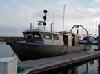
24 meter pilot vessel (79 feet long; beam 23.5 feet; draft 8 feet) MBARI, Moss Landing. Acquired by MBARI 2001, originally name San Francisco. Retired October, 2012 from MBARI. Purchased from MBARI by Outbound Marine LLC in 2013.