| Identifier | 2013-044-FA | ||||||||
|---|---|---|---|---|---|---|---|---|---|
| Purpose | Collect sediment samples, photos, video, and ctd data for substrate mapping on Stellwagen Bank in collaboration with Stellwagen NMS scientists. | ||||||||
| Location | Stellwagen Bank, Massachusetts, United States, North America, Gulf of Maine, North Atlantic;, | ||||||||
| Summary | Conducted 3 1-day cruises with RV Auk to Stellwagen Bank from Scituate, MA. Collected sediment samples, video and photo imagery, ctd water column profiles, navigation data. | ||||||||
| Info derived | Grain size analysis;Sea floor map; | ||||||||
| Comments | Mobilization will be on Friday, Nov 1 at the SBNMS dock at 75 Edward Foster Road, Scituate, MA. Demob at the same location. RV AUK is the SBNMS research vessel; 50 ft catamaran. Actual cruise dates were Nov 5, 15, and 21, 2013 Project = New England Benthic Habitats, | ||||||||
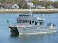
| Platform |
|
||||||||
| Itinerary |
|
||||||||
| Bounds |
|
| Organization |
384 Woods Hole Road
Quissett Campus
Woods Hole, MA02543-1598
(508) 548-8700
|
||
|---|---|---|---|
| Principal investigators | Page C Valentine | ||
| Crew members |
|
||
| Information specialist(s) |
|
||
| Affiliate principal | Dr. David Wiley, Stellwagen Bank NMS |
| Data category: | Location-Elevation, Biological Field Study, Imagery, Sampling, Visual Identification, Environmental Data |
|---|---|
| Data type: | Navigation, Experiments (biological), Surveys (biological), Photo, Video, Biology, Geology, Species ID, CTD |
| Name | Description |
|---|---|
| Cruise log - vol. 2 | Volume 2 of the acquisition and observation logs for seabed video and sediment samples collected aboard the R/V Auk on Stellwagen Bank. |
| Cruise log - vol. 1 | Volume 1 of acquisition and observation logs for seabed video and sediment samples collected aboard the R/V Auk on Stellwagen Bank. |
| Equipment | Usage description | Data types | Datasets |
|---|---|---|---|
| Furuno satellite compass SC-30 | The location information for stations was acquired from a satellite navigation receiver (Furuno satellite compass SC-30, GPS receiver) at one second intervals. | Navigation | 1 |
| SBE 19plus V2 SeaCAT Profiler CTD | These data were collected with a Sea-Bird CTD (conductivity, temperature, depth) instrument - a SBE 19plus SeaCAT Profiler CTD. In addition to the CTD water column profiling, the CTD is equipped with auxiliary sensors to measure fluorescence and turbidity. This instrument was deployed on the USGS SEABed Observation and Sampling System (SEABOSS). The CTD is mounted horizontally on the SEABOSS frame and its maximum depth is approximately 1 meter above the seabed. | CTD, Fluorescence, Turbidity | 1 |
| Canon G12 | The camera was mounted on SEABOSS and used to take photos of the sea floor. The quality of the photos was extremely poor, so frame grabs of the GoPro video are used to provide the seabed still photos. | Photo | (no data reported) |
| SeaBOSS | The SEABed Observation and Sampling System (SEABOSS) was used to collect sediment samples with a modified Van Veen sampler and video images of the seabed with GoPro cameras mounted on the frame. A CTD was mounted horizontally on the SEABOSS frame and its maximum depth is approximately 1 meter above the seabed. | Surveys (biological), Experiments (biological), Species ID, Photo, Video, Geology, Biology | 2 |
| GoPro camera | Seabed video images were collected using a GoPro digital video camera mounted on SEABOSS to provide ground-truth information for geophysical datasets and are used in seabed interpretations. Frame-grab images were extracted from the video. | Photo, Video | 2 |
| Dataset name | Equipment | Description | Dataset contact |
|---|---|---|---|
| 2013-044-FA_nav | Furuno satellite compass SC-30 | Navigation data collectd aboard the R/V Auk on Stellwagen Bank (Geographic, WGS 84, XLSX and CSV formats). | Page C Valentine |
| 2013-044-FA_CTD | SBE 19plus V2 SeaCAT Profiler CTD | Conductivity-temperature-depth data, along with fluorescence and turbidity data were collected aboard the R/V Auk on Stellwagen Bank. | Page C Valentine |
| 2013-044-FA_station_summary | SeaBOSS | Station and data summary for data collected aboard the R/V Auk on Stellwagen Bank. | Page C Valentine |
| stellwagen_2013_2019_sedsamps | SeaBOSS | Location and analyses of sediment samples collected aboard the R/V Auk on Stellwagen Bank. The dataset contains samples from multiple cruises. | Page C Valentine |
| 2013-044-FA_SeabedImages | GoPro camera | Seabed still images collected aboard the R/V Auk on Stellwagen Bank (JPEG image format. EXIF headers have been added to include navigation and other meta tags). | Page C Valentine |
| 2013-044-FA_video_driftlines | GoPro camera | Video transects of the sea floor collected aboard the R/V Auk on Stellwagen Bank. | Page C Valentine |
| Dataset name | Description | Dataset contact |
|---|---|---|
| q5_geologic_interp | Interpretation of the seabed geologic substrates in quadrangle 5 of the Stellwagen Bank National Marine Sanctuary region offshore of Boston, Massachusetts based on data collected by the U.S. Geological Survey from 1993-2019. | Page C Valentine |
| q5_stations_geology | Station locations in quadrangle 5 in Stellwagen Bank National Marine Sanctuary offshore of Boston, Massachusetts where video, photographs and sediment samples were collected by the U.S. Geological Survey from 1993-2015 - includes sediment sample analyses and interpreted geologic substrate | Page C Valentine |