| Description |
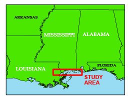
In June and August of 1992, the U.S. Geological Survey (USGS) conducted geophysical surveys to investigate the shallow geologic framework from Lake Pontchartrain, Louisiana, to Mobile Bay, Alabama. This work was conducted onboard the Argonne National Laboratorys R/V ERDA-1 as part of the Mississippi/Alabama Pollution Project. This report is part of a series to digitally archive the legacy analog data collected from the Mississippi-Alabama SHelf (MASH). The MASH data rescue project is a cooperative effort by the USGS and the Minerals Management Service (MMS). This report serves as an archive of high resolution scanned Tagged Image File Format (TIFF) and Graphics Interchange Format (GIF) images of the original boomer paper records, navigation files, trackline maps, Geographic Information System (GIS) files, cruise logs, and formal Federal Geographic Data Committee (FGDC) metadata. For more information on the seismic surveys see http://woodshole.er.usgs.gov/operations/ia/public_ds_info.php?fa=1992-010-FA and http://woodshole.er.usgs.gov/operations/ia/public_ds_info.php?fa=1992-037-FA These data are also available via GeoMapApp (http://www.geomapapp.org/) and Virtual Ocean ( http://www.virtualocean.org/) earth science exploration and visualization applications. [More]
|
